Before we set off, I thought I would post some pre-walk statistics based on my walk to work this morning:
Distance logged by Garmin GPS = 10.1 km
Steps recorded by Nike Fuel Band = 10,800
= 1,069 steps per km
Distance from John O'Grats to Land's End = 1,760 km
Therefore, the number of steps required to walk the distance is 1,760 x 1,069 = 1,881,440
So, near enough 2 Million steps......with a back pack.

Monday, 17 June 2013

Saturday, 15 June 2013
Final Preparations
With just a few days to go now, I am delighted to say that we have received lots of incredibly generous donations for our charities from friends, family and work colleagues. By the time we finish our walk we are guarenteed to be handing over a fantastic total to Willen Hospice and Help for Heroes.
We are now in the process of final checks to kit to try and decide what is essential and what can be left behind. Over the course of the last year, all kit has been carefully researched and chosen based mainly on being as light as possible. The one exception being the rucksack, the MacPac Torlesse 50 is not the lightest, but it has a very comfortable harness and looks to be robust enough for a trip like this. My pack is still heavier than I would have liked and looks like it will be near to 14kg which I can testify is a bit like carrying a 5 year old child around on your back and not something to relish doing for 25 miles at a time, although at least my pack won't be saying "are we nearly there yet?" for the whole journey.
Kit worries aside, I'm happy that I have done enough walking in training to prepare myself for this. The walks to work and back are good preparation and prove a time efficient training method. The biggest worries are always going to be illness or injury, either of which are capable of ruining the best laid plans. If necessary we may need to be flexible and revise daily mileages and rest.
Worries asside, this walk has been a long time in the planning and I can't wait to just get going now!
We are now in the process of final checks to kit to try and decide what is essential and what can be left behind. Over the course of the last year, all kit has been carefully researched and chosen based mainly on being as light as possible. The one exception being the rucksack, the MacPac Torlesse 50 is not the lightest, but it has a very comfortable harness and looks to be robust enough for a trip like this. My pack is still heavier than I would have liked and looks like it will be near to 14kg which I can testify is a bit like carrying a 5 year old child around on your back and not something to relish doing for 25 miles at a time, although at least my pack won't be saying "are we nearly there yet?" for the whole journey.
Kit worries aside, I'm happy that I have done enough walking in training to prepare myself for this. The walks to work and back are good preparation and prove a time efficient training method. The biggest worries are always going to be illness or injury, either of which are capable of ruining the best laid plans. If necessary we may need to be flexible and revise daily mileages and rest.
Worries asside, this walk has been a long time in the planning and I can't wait to just get going now!
Thursday, 13 June 2013
One Week to go - New Boots
I can't quite believe it, but with just one week to go before starting an 1100 mile walk, I'm buying new boots! I know that this is a classic mistake that could end up with nasty blisters on the first day, but I don't really have any alternative. I had planned to set off in a pair of Salamon Quest 4D GTX boots that I bought last summer and have spent the best part of a year breaking in and until now feeling very comfortable with. However, in the last week during my daily 20K walks to and from work, I have inexplicably started feeling my toes touching the end of the boot. I can only think that my feet have expanded with the extra walking. Either that, or the boots have somehow shrunk. Either way, this it is a problem that can only be resolved by buying new boots. I have decided to get the same model again, half a size bigger and to see if I can break them in in the 7 remaining days. If not, then I'm going to be in for an especially painful first week or two of this trip!
Wednesday, 5 June 2013
Blister Prevention
Thanks to Nick for sending me a lovely picture of what happens to your toe nails if you walk for 20 miles in ill fitting boots. After careful consideration, I have decided not to share this on my pages. However, it has spurred me to buy some Leukotape, hopefully this will be slightly better than wrapping my feet in gaffa tape which has been suggested by some people.
Monday, 3 June 2013
Daily Schedule
Daily Schedule
01 John o'Groats to Mid Clyth - 26
Miles - 8 Hours
|
02 Mid Clyth to Helmsdale - 30 Miles
- 11 Hours
|
03 Helmsdale to Dornoch - 30 Miles -
9 Hours
|
04 Dornoch to Alness - 21 Miles - 7 Hours
|
05 Alness to Inverness - 20 Miles - 7
Hours
|
06 Inverness to Balbeg - 30 Miles -
10 Hours
|
07 Balbeg to Clunes - 30 Miles - 11
Hours
|
08 Clunes to Fort William - 18 Miles
- 6 Hours
|
09 Fort William to Kingshouse - 25
Miles - 9 Hours
|
10 Kingshouse to Tyndrum - 19 Miles -
6 Hours
|
11 Tyndrum to Inversnaid - 21 Miles -
9 Hours
|
12 Inversnaid to Drymen - 20 Miles -
8 Hours
|
13 Drymen to Twechar - 24 Miles - 7
Hours
|
14 Twechar to Linlithgow - 25 Miles -
8 Hours
|
15 Linlithgow to Edinburgh - 23 Miles
- 8 Hours
|
16 Edinburgh to Peebles - 22 Miles -
7 Hours
|
17 Peebles to Melrose - 25 Miles - 7
Hours
|
18 Melrose to Jedburgh - 16 Miles - 5
Hours
|
19 Jedburgh to Byrness - 21 Miles - 7
Hours
|
20 Byrness to Bellingham - 17 Miles -
6 Hours
|
21 Bellingham to Haltwhistle - 20
Miles - 7 Hours
|
22 Haltwhistle to Alston - 14 Miles -
5 Hours
|
23 Alston to Langdon Beck - 17 Miles
- 5 Hours
|
24 Langdon Beck to Bowes - 23 Miles -
8 Hours
|
25 Bowes to Hawes - 26 Miles - 8
Hours
|
26 Hawes to Horton-in-Ribblesdale -
14 Miles - 5 Hours
|
27 Horton-in-Ribblesdale to Skipton -
25 Miles - 8 Hours
|
28 Skipton to Hebden Bridge - 25
Miles - 8 Hours
|
29 Hebden Bridge to Diggle - 17 Miles
- 6 Hours
|
30 Diggle to Padfield - 18 Miles - 7
Hours
|
31 Padfield to Edale - 21 Miles - 7
Hours
|
32 Edale to Castleton - 5 Miles - 2
Hours
|
33 Castleton to Dovedale - 29 Miles -
9 Hours
|
34 Dovedale to Uttoxeter - 16 Miles -
6 Hours
|
35 Uttoxeter to Penkridge - 27 Miles
- 9 Hours
|
36 Penkridge to Wolverhampton - 11
Miles - 3 Hours
|
37 Wolverhampton to Bewdley - 27
Miles - 9 Hours
|
38 Bewdley to Worcester - 21 Miles -
7 Hours
|
39 Worcester Tewkesbury - 20 Miles -
7 Hours
|
40 Tewkesbury to King's Stanley - 26
Miles - 8 Hours
|
41 King's Stanley to Old Sodbury - 22
Miles - 7 Hours
|
42 Old Sodbury to Bath - 18 Miles - 6
Hours
|
43 Bath to Midsomer Norton - 11 Miles
- 4 Hours
|
44 Midsomer Norton to Glastonbury -
20 Miles - 7 Hours
|
45 Glastonbury to Taunton - 21 Miles
- 10 Hours
|
46 Taunton to Tiverton - 26 Miles - 9
Hours
|
47 Tiverton to Crediton - 17 Miles -
6 Hours
|
48 Crediton to Oakhampton - 23 Miles
- 8 Hours
|
49 Okehampton to Launceston (part2) -
7 Miles - 3 Hours
|
50 Okehampton to Launceston (part1) -
16 Miles - 5 Hours
|
51 Launceston to Bodmin - 32 Miles -
10 Hours
|
52 Bodmin to Truro 28 Miles - 9 Hours
|
53 Truro to Helston - 19 Miles - 6
Hours
|
54 Helston to Penzance - 19 Miles - 7
Hours
|
55 Penzance to Land's End - 10 Miles
- 6 Hours
|
Wednesday, 22 May 2013
What Route to Take
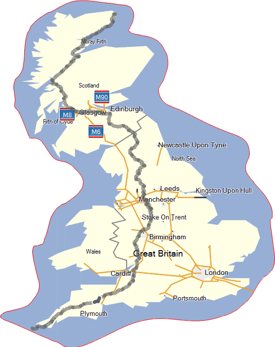
What Route to Take
In the previous "General Considerations" post I weighed the pros and cons of LEJOG vs JOGLE. There are many permitations of what overall route to take, for example, some people choose to do the entire journey by the shortest possible route, sticking to A roads. This for me sounds like hell and I would need to question the reason for undertaking the journey in the first place if all I was going to see was a constant stream of heavy traffic. Some of the main route planning questions I asked myself when planning the route were as follows:- Should I make use of long distance footpaths like the Pennine Way, Great Glen Way, Cotswold Way etc. or stick to footpaths and bridleways, quiet roads and Sustrans routes?
- Should I divert around the busy A9 & A99 in Scotland, adding an extra day to the journey?
- Should I follow guide book routes or published GPS trails of others that have completed the walk?
- How many miles should I cover in a day?
(I have decided to have a daily target of 25 miles, this will cover the 1,100 miles in 44 days).
Route Planning
So where do you start when trying to plan such a long route? Well, the answer is that there is enough information available to mean that you do not need to scrutinise OS maps and work out a detailed route yourself. Instead, you can check out some of the published routes of people who have done this before. Some of the books that almost everyone undertaking this challenge seem to come across are as follows:- The Land's End to John O'Groats Walk by Andrew McCloy ISBN-10: 1871890594
- The End to End Trail by Andy Robinson ISBN-10: 1852845120
- John O'Groats to Land's End: The Official Challenge Guide by Brian Smailes ISBN-10: 1903568188
The most useful resources that I found when researching the route were blogs and published GPX tracks from people who had completed the journey. I managed to find a complete published track across the country which I used as the basis of my route. It was still necessary to reverse the route for each day, tidy up any diversions, waymark campsites etc. but having the entire route essentially in place was invaluable. I shall include my own route for download if and when I complete it successfully.
Websites that proved incredibly useful when planning this trip were the following:
Thursday, 16 May 2013
General Considerations
General Considerations
When considering travelling the length of the country, there are many things to consider, here are a few of my thoughts around the challenge.Mode of Transport
The End to End challenge has been done in more ways than you could imagine, some so bizzare, the mind boggles as to how on earth they could be done, these include:- Skate board
- Pogo stick
- Wheel barrow (two brothers who then changed over and went back the other way)
- Teeing a golf ball all the way
- By bus pass
- Cycling - 10 to 20 days
- Running - 30 to 40 days
- Walking - 45 to 55 days
North South, or South North
This is always a matter of much debate, most people seem to do LeJog rather than JogLe. If I was on bike then this would definitely be a LeJog to take advantage of the prevailing winds, but on foot that's not so important. In the end, it is a matter of personal preference and there is no right or wrong way to go.Here are some of the pros & cons:
South - North (LeJog)
Pros:
- Prevailing winds - can save a whole day if on bike.
- Maps will always be the right way up.
- Established route guides in this direction.
- Sun on your back rather than in your face.
Cons:
- It gets cooler as you head North.
- Some big hills and midges saved for the end.
North - South (JogLe)
Pros:
- It gets warmer as you travel South.
- Gets midges and the busy A9 and A99 out of the way in the first week.
- You get to finish the walk in surfer country.
Cons:
- The sun and wind will be in your face.
- Maps will always be upside down.
Alone or Accompanied
Many people choose to do this walk alone, possibly because they can't find anyone else mad enough, or able to spare the time off work to join them. The prospect of travelling 1,100 miles on foot alone could be quite daunting to many people and perhaps the monotony of some parts is better having someone to share the experience with. Ultimately this is a matter of whether you think that you need a travelling companion, or prefer break the trail and its many experiences alone.Conclusions
I decided to do JogLe rather than LeJog because I wanted to finish in a warmer part of the country where I'm used to having summer beach holidays and because I've done LeJog before, so this would be a different experience. The prospect of doing the journey by foot is certainly a daunting one, but many people complete this challenge every year and some people do it in ways that make my attempt look like a Sunday afternoon stroll!
Subscribe to:
Posts (Atom)